
As we trudged into Gorakshep (5,164 m / 16,942ft), literal meaning ‘Dead Crow’, sucking in mouthfuls of air with only around 54% the oxygen at sea level, already weary and only 12 o’clock, we knew it would be a long day. It was Everest Base Camp (EBC) day, the day that promised to make the sweat, aches and breathlessness all worth it. We had already lost one member of our team, Bhav, to a helicopter evacuation on account of Acute Mountain Sickness (AMS) somewhere earlier that day near Lobuche. As we flopped down onto familiar carpeted seats in the teahouse and struggled to stomach our lunches, we knew that we would have to push ourselves hard. But as we set off again for EBC, the sun shone and the mountains towered over us, pushing us onward. We tackled another hour of rock, shingle and yak traffic before we got our first glimpse of Everest, who for an 8,848m / 29,029 ft peak, had been surprisingly shy for the whole trip. Slowly, slowly those yellow tents at base camp became larger, the perilous seracs on the infamous Khumbu Icefall became clearer, and we found the energy to trudge on.
Trekking Itinerary
Day 1: Kathmandu – Lukla (2,845m / 9,334ft) – Phakding (2,610m / 8,562ft)
Day 2: Phakding – Namche Bazaar (3,440m / 11,286ft)
Day 3: Acclimatisation day in Namche – “climb high, sleep low”
Day 4: Namche Bazaar – Tengboche (3,867m / 12,687ft)
Day 5: Tengboche – Dingboche (4,410m / 14,468ft)
Day 6: Acclimatisation day in Dingboche
Day 7: Dingboche – Lobuche (4,940m / 16,210ft)
Day 8: Lobuche – EBC (5,364m / 17,598 ft) via Gorakshep (5,164m / 16,942ft)
Day 9: Gorakshep – Kala Patthar (5,643m / 18,513ft) – Pheriche (4,371m / 14,340ft)
Day 10: Pheriche – Namche Bazaar
Day 11: Namche Bazaar – Lukla
Day 12: Lukla – Kathmandu


My first challenge was leaving the safety and air conditioning of my hotel room in Kathmandu for the dusty, dirty and ‘try-not-to-get-run-over-by-a-car-or-moped-before-you-have-even-started-trekking’ streets. Travelling solo for my first foray with Asia, hit by the culture shock, I felt truly out of my comfort zone. I managed a day of somewhat meekly exploring Thamel before the next day when we met our team and had a day of proper sightseeing in Kathmandu with a guide, organised by the owner of Himalayan Scenery Treks and Expedition, Ram Krishna. Early (and not so bright) the morning after, as our team gathered at Kathmandu airport aiming for the first flight to Lukla on Nepal Airlines, we were a gaggle of nervous excitement. We had all read about the Tenzing-Hillary airport at Lukla, aptly named after Sherpa Tenzing Norgay and Sir Edmund Hillary, the first to summit Everest in 1953, and who also pretty much came up with the idea of putting a runway here in the first place. The idea was to make the job easier for the transporting of building works to the area for the schools and hospitals The Himalayan Trust had funded (a charity Hillary had founded). Also affectionately known as one of the most dangerous airports in the world thanks to its 527m runway (just one tenth of the normal length), a 11.7% gradient, and with no radar system due to the cost of installation, the pilots rely solely on their visuals and radio guidance. Once committed to landing, there is no option for a ‘go around’ due to the high terrain at the north end of the runway, and the steep drop at the south.

Clearly, my excitement had got the better of me as I made a bee-line for the front seat. With knees jammed next to our neighbours, cotton wool stuffed in our ears, and sucking on boiled sweets that the stooped stewardess (yes, a stewardess) had handed us, we were directed to frayed safety cards in our seat pockets while our stewardess gesticulated a little before she was drowned out by the sound of the propellers.
Despite the cloud that shrouded much of our views, on the steep descent for landing the cloud cleared and our Twin Otter touched down (relatively) gently. Before the propellers even stopped turning, the doors were open and we were ushered out onto the runway, in awe of the sudden mountains, valleys and skylines that surrounded us. At Lukla airport I experienced the first (of many) squat toilets. We walked round to a teahouse pitstop where we drank our first (of many) hot lemon and honey teas while waiting for our bags to arrive (some had not made it onto our flight). We watched many a take off, standing directly behind each little plane as it blasted its engines, brakes on, before being let loose down the sloping runway, before lifting off what looked like a mere metre from the end of the runway. We watched smugly, thinking of all of the long days between us and having to face that ride.

While waiting for our bags, I loitered next to some local children before making friends with them. They were brother, sister and friend, having finished school for the day (at 9am..?) and were now collecting rocks in small sacks on their backs for nearby building works. The oldest spoke excellent English at 9, having been taught by her father, a mountain guide. She dreamt of moving to Kathmandu when she was older.

Our bags having arrived, I clumsily set up my hydration bladder for its first proper outing, tasted my first sip of chlorinated water (I had opted for sterilisation tables to save money (and the planet) on bottled water), and we set off for the shortest trekking day of the trip – just a few hours to Phakding (2,610m / 8,562ft). The route was glorious, predominantly downhill (this surprised my naive brain that assumed that we would be ascending all day every day), green, smelt of pine forest and was accompanied by the sound of a crashing river. We arrived at Phakding for lunch where I was surprised at the variety on the menu. What we soon found out, though, was that this menu stays largely the same for the entirety of the trek. How quickly fried food lost its appeal!

I went to explore my room for the night with Bex, and as we hysterically joked about the huge padlock on the wooden door, the gaps in the window frame, and the mouse sized hole in the wall, we were approached in the corridor by an Australian woman, on her way down from EBC with her family, who proceeded to put the living fear of God into us about the trip. Everybody will get sick, everybody will freeze, you won’t be able to breathe at night, the accommodation will always be horrific, I wouldn’t be able to ascend the hill to Namche Bazaar without trekking poles, our gear wasn’t good enough…and so it continued. I’m paraphrasing, seriously. After lamenting to the others over dinner about her attitude, horrified that our first encounter with trekkers on the way down had been so negative, we agreed that a positive mental attitude would be half of the battle getting up to EBC, and down again, still sane. Everybody else we met coming down was positive and more realistic. I think that everybody is somewhat naive coming onto this trek – after all, there is only so much reading you an do to prepare yourself and the reality is still a shock – but you should know that you do not come to do this trek looking for comfort and luxuries. Half of Nepalese people won’t get dinner tonight – be glad that you have an extensive menu, bed and roof over your head.
“Your attitude, not your aptitude, will determine your altitude.” Zig Ziglar
That first night I was cold, and from then onwards I always slept with at least one duvet over my sleeping bag, two if available (generally I had a twin room to myself; two beds, two duvets – bonus). Come morning I had porridge for breakfast. I figured that if I had the same breakfast as Narayan (our lead guide), I would have the same energy he had (ha!). By 8am we were off, first proper day of trekking and off to the relative bustle of Namche (3,440m / 11,290ft) via the dreaded hill that without poles would be “impossible”. Again the weather Gods were on our side: glorious sunshine, the odd cloud and our first suspension bridge adorned with prayer flags pulling in the wind. We soon learned that whenever Narayan described the route as “undulating”, this was in fact a gross misrepresentation of what in fact would feel like climbing up and down Everest all afternoon. This theme continued throughout the trek. We soon found that our group split naturally into two different walking paces. Govinda led our Front Team, and Narayan the Back Team who preferred to stop more frequently for photos and general merriment. We passed through checkpoints as we entered Sagarmatha National Park, posing for a (Front) Team shot in front of the sign at Monjo (2,855m / 9,366ft).

At the checkpoint we were met with a peculiar sight: a very British looking tourist riding a tiny pony being pulled along by a Nepalese man. He dismounted and approached us with a limp, full of stereotypically British stoic positivity and self-deprecation. He had made it all the way to EBC but rolled an ankle trekking down, and was now subjected to a $200 ride all the way back to Lukla (well, it is cheaper than a $5000 chopper evac). He was 100 times more positive than the Australian woman. After wishing each other well we set off, spinning every prayer wheel we walked past (in case not doing so would jinx us to a miserable trip defined by AMS and gastro problems). We made it to our lunch stop at Jorsalle (2,740m / 8,989ft), then onwards to the iconic Hillary-Tenzing suspension bridge, hanging above the now derelict older one, then onto the now infamous hill into Namche.

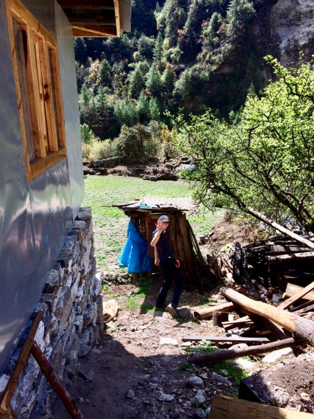
The hill was very long, very dusty, and we were very glad to get to the top of it. And without poles too, Australian woman! We reached Namche (3,440m / 11,286ft) at around 16:00 where we were greeted by a plethora of yak/cow hybrids, donkeys, stray dogs, fellow trekkers, locals and shops – this was the last place to buy anything we might need for the rest of the trek. After getting settled at the aptly named Foot Rest Lodge, I had a ‘baby wipe shower’, the kind of cleaning routing that would see me through the next two weeks, and settled in the dining area with the rest of the team to capitalise on the only free wifi hotspot of the trip to inform worrying family members back home that we were, in fact, still alive. That evening Bhav, part of Back Team, braided my hair, a ‘style’ that I would eke out for the next 10 or so days. I learned of Bhav’s trekking partner and friend, Habiba’s, cause for participation: in memory of her older sister who had died of bowel cancer. Habiba had already raised £10,000 in her memory.

The next morning was the first of our ‘rest’ days; the illusion of a cosy day spent exploring Namche was shattered earlier in the trip when I realised with some horror that ‘rest’ is just a glitzed up word for ‘acclimatisation’, which I soon found out actually meant climbing up as far as possible, staying there for a while, and then coming back down again. Again the weather was on our side, a cloud mottled sky interspersed with strong sun. We climbed up through Namche, up a bit more, along a bit more, up a bit more (you get the idea) all the way up to Hotel Everest View, at 3,880m / 12,729ft, the highest hotel in the world. There, as we sat outside, Everest itself hid behind a huge cloud, but we were in awe of Lhotse (8,516m / 27,939ft), the fourth highest mountain in the world, and Ama Dablam (6,812m / 22,349ft) who would be our most prominent mountain friend for the next few days. After some drinks, some time to allow our bodies to acclimatise, and some more conversations revolving around our luck and privilege to be here, we headed back down to Namche. We spent the afternoon sat outside in the sun with our various solar chargers, trying to eke out our batteries to delay the inevitability of paying to charge. Several travellers on the way down had told us of heavy snowfall at EBC, so I bought some gaiters and another pair of thicker gloves. Dealing with wet socks and/or frozen hands at EBC was not on my agenda.

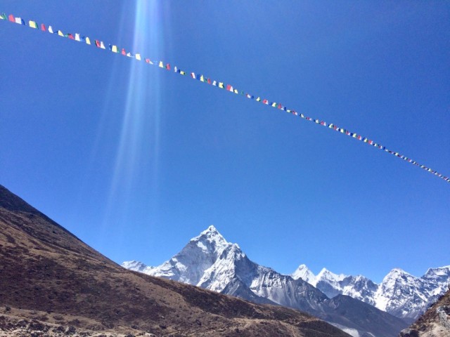
The next morning, a few of us had developed coldy and chesty symptoms. We put this down to our clearly inadequate layering systems. Although there was a strong sun, we had found that as soon as you stop walking, the wind hits you. As Narayan told us at breakfast, it is always better to wear too much than too little in the mountains. My symptoms developed into a full blown cold, then chesty cold and then wheezy cough. But as I repeated to the rest of the team – I would consider myself lucky if this was ‘all’ I had to deal with in the mountains. Bex, Bhav and Habiba were all suffering to varying degrees with the altitude already – headaches, loss of appetite, nausea. I was very lucky in comparison. Following another porridge breakfast (the boys were much more adventurous with Tibetan bread and eggs, those feeling nauseous could only nibble on toast), we were off en route to Tengboche (3,867m / 12,687 ft). The route was a winding mountainous path, scattered with stupas and prayer flags adorned with mantras, the idea being that when the flags blow in the wind, the mantras of compassion and good will will be spread to all prevailing space. We were gradually ascending before a steep descent to the Dudh Koshi river for a lunch stop, before another big climb (400m) up to Tengboche. Looking back through the valleys, we could see the two suspension bridges from the previous day, and looking forwards we could see Tengboche nestled on top of a ‘hill’ from quite early on. We mused that a very long suspension bridge connecting Namche and Tengboche to avoid all of the ups and downs would be an excellent project for the Nepalese government.


After our lunch pit-stop, and a sneaky chocolate brownie from Riverside Bakery to further fuel me up the hill, Back Team caught us up and Front Team faced the hill. For about 15 minutes, it was very slow and very painful. We were all struggling to catch our breath. The dust meant that I was wearing my buff over my nose and mouth (essential for the packing list, people), and I remember wondering if this was further impeding my oxygen supply. We then decided that it might be helpful if we sang our way up, and we spent the next hour or so singing our gasping renditions of Bohemian Rhapsody (“body’s aching all the time…”) amongst other ballads which, surprisingly, distracted us from the pain, lifted our spirits dramatically, and had fellow trekkers joining in (and filming) left, right and centre. Finally, we dragged our boots into Tengboche. You’ll know you’ve arrived because the hill stops and there are some buildings. The plan for later that afternoon was to wait for Back Team to arrive, then visit the Tengboche Monastery. I was feeling pretty grotty at this stage, however, as having finished trekking and sitting with Front Team in the cold dining area, I slowly froze. Snotty, chesty, very cold and very little appetite (it look me close to an hour and a half that evening to force down half a pizza), I therefore opted for an hour horizontal on my bed, with two duvets over me, reading my Kindle. At last I was warm! The advice at altitude is not to sleep during the day, as your body gets even less oxygen and struggles even more to acclimatise. The others enjoyed the monastery and we re-grouped for dinner.

The next morning was the first day I resorted to two layers of trousers: a pair of insulated winter running leggings, and a waterproof fleece lined pair of walking trousers on top. It was also the first misty and (a little bit) rainy day. After a slightly chaotic start, where Habiba and Bhav set off walking in the wrong direction, we re-grouped and set off for Dingboche (4,410m / 14,470ft). After an hour or so, the weather cleared and we were stripping layers again. With my chesty cough, I was struggling to take deep breaths and was feeling the reduced oxygen acutely. By lunchtime, the weather had come in again, and visibility was very low. Even the constant stream of helicopters ferrying goods up and (ill trekkers) down the mountains slowed down. After our first ‘yak attack’ encounter, where we somehow found the energy to run very quickly uphill and jump out of the way as a mob of yaks ran very quickly downhill, the rest of the afternoon we felt like we were trekking in the Peak District: the ground was mossy, there were no trees (above ~4000m / 13,123ft conditions are too extreme for trees to grow), it was drizzling and we were looking forward to our accommodation at Dingboche.

After arriving at Hotel Good Luck, Dingboche (4,410m / 14,468ft), the rest of the afternoon followed the usual pattern of sitting in the dining area struggling to stay warm, chatting, reading, writing and playing cards. Back Team arrived an hour or so after us, with Bex in particular now really struggling with the altitude. The next morning Narayan would advise her to descend with a porter and guide, but she persevered and made it to EBC, all in aid of Breast Cancer Research, before a swift helicopter evac the next morning. Most others, Becky in particular, would also wake with terrible headaches each morning, only alleviated by a mix of the strongest painkillers and getting on the trail (being out in the fresh air seemed to help – more oxygen outside?!). I kept counting my blessings – so far I was immune to any terrible altitude sickness symptoms.
That evening the mist would clear, and David would brave the arctic temperatures to set up his tripod and camera and take some incredible shots of the mountains illuminated by the stars.

The next day was another acclimatisation day, though Bhav, Habiba and Bex were too ill to partake. Having spent the day truly resting, they all felt moderately better that evening. We set off early to climb 4,700m / 15,419ft up Nagarsang, the peak immediately next to our dwelling. It was tough going (but then what wasn’t?), but we reached our destination, greeted by a swathe of prayer flags and mountain vistas. We were then given the option of summiting Nagarsang which at 5,200m / 17,060ft would mean an 800m ascent in one morning. What I have learned about my character over the last few years is that I find it very hard to say ‘no’. To people, adventures, and summits. Evidently, so too do Nick, Becky and David. After perhaps an hour and a half of what Nick aptly termed “pain and suffering” (no exaggeration), unable to set ourselves a pace slow enough to both shuffle upwards whilst still sucking in enough oxygen (at this altitude, about 59% of sea level), we summited, and the pain and suffering were all worth it. The clouds had surrounded us so that we couldn’t see a thing from the top, but we didn’t care. The elation and sense of achievement was overpowering. Our bodies had adapted, ferried us up this huge rock with limited oxygen and we had not keeled over. Success! Once again I was struck with the knowledge of how lucky I was to be doing this, privileged to have a body capable of letting me achieve my dreams.
“High altitude climbing is like hitting your head against [a] wall, they both feel good when you stop.” Unknown. (I didn’t make it up, I promise. I may as well have though, it’s true).


The next day, aiming for Lobuche (4,940 m/ 16,210ft), we were blessed with the first properly clear day, not a cloud in the sky, and we were treated to the views that we had missed at the summit of Nagarsang. After a relatively easy morning of “undulating alpine meadows” (Naryan’s take on the trekking), we arrived at Thukla (4,620m / 15,157ft) for lunch where a cheese toastie was most welcome, and Front Team sat outside harnessing the sun’s rays for our solar panels. After lunch was a bit of a mean ascent, where we were greeted by the Thukla Pass and eerie memorials for those who have died on Everest and nearby mountains; “sleeping forever on the (sic) Everest”. Among them, Scott Fischer and Rob Hall from the doomed ’96 year. The danger and fragility of our environment was becoming harder to ignore.


Having arrived at Lobuche, we barely had time for a hot honey lemon and to catch our breath (metaphorically, of course) before we were off on another acclimatisation hike, this time just up a nearby hill for views of the Khumbu Glacier that stretched right the way down from Everest past Lobuche. I went without my rucksack for the first (and only) time, and felt liberated and free. It makes a difference, not carrying that weight around here. And I had packed very light: I carried the larger of my rucksacks, Govinda carried my other small rucksack. Most others had a large duffel bag which the porters carried, and had access to more snacks and clean clothing.
That night spent at Lobuche was the only night that Narayan gave us his room number for altitude related emergencies in the middle of the night. We would later learn, safely on the way down from EBC and under 3000m again, that on one of Narayan’s previous EBC treks a tourist had died, having been struggling with the altitude but not told anybody, he then became severely unwell at 3am at Lobuche. Despite their best efforts to carry him down in the night, he collapsed and died from High Altitude Pulmonary Edema (HAPE), an accumulation of fluid in the lungs.
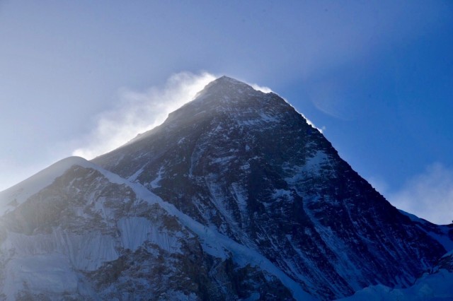
The next day was the big one, April 26th and EBC. I awoke indulged with another clear head, and to the sound of a chopper evac, and hung out of the window to watch the chopper take off into clear blue skies. A quick babywipe wash later (these were becoming more and more infrequent on account of the cold), breakfast, and we were off, earlier today (7:30) en route to Gorakshep (5,164m / 16,942ft). By now, the landscape was desolate, and to me looked like a combination of the surface of the moon, and Frodo’s route to Mordor. The surrounding mountains however, Khumbutse (6,636m / 21,771ft), Lhotse (8,516m / 27,940ft), Nuptse, (7,861m / 25,791ft), and Pumori (7,161m / 23,494ft), in particular, more than made up for it. That afternoon we would catch our first glimpse of Everest (8,848m / 29,029ft), also known as Sagarmāthā (“Forehead in the Sky”) and Chomolungma (“Mother of the World”). We would also catch our first sightings of EBC, a smattering of yellow tents barely visible to the naked eye, hunkered below towering peaks. We learned before reaching Gorakshep about Bhav’s chopper evac somewhere near Lobuche. Little did we know that we would lose Bex and Habiba to the same fate, both within the next 24 hours.

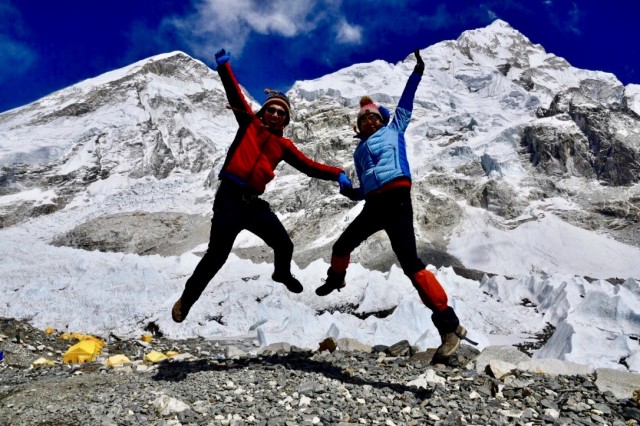
We arrived into EBC (5,364m / 17,598ft) in a sort of surreal state. Clambering over the rocks and shingle, I noted a deep chasm a couple of metres to the left of our path, large and black enough to swallow two people. The final few uphill strides into camp were easy, and we were at EBC at the perfect time of year to see a plethora of tents housing the proper guys who were acclimatising and preparing to summit. The skies were an azure blue and we had excellent visibility, although typical of the climate here, the afternoon clouds soon began to roll in. Reaching EBC itself is more about being able to say to yourself (and anybody at home that will give you the airtime) that you have been there, and less about the views of Everest. Yes, the views are incredible, but contrary to what you might think, you cannot actually see Everest from EBC. I know, I know. We congratulated each other and jostled with other groups to take photos un-marred with other trekkers.

Back at the teahouse later that afternoon, there were only a few people on the planet that I wanted to share our achievement with, the two foremost being my poor parents who had been biting their nails at home in radio silence for the past few days. I forked out on a wifi pass and Nick and Becky wished me luck (a recurring theme of this trip has been intense emotional interactions with loved ones at home). An indication of the amazing people I was able to share this experience with, post-conversation with parents at home, my snivelling self was greeted with two squares of precious Cadbury’s chocolate at my place at the table, courtesy of Becky and Nick. As predicted, it took but hearing my parents’ voices for the emotions of the trek to come flooding out. After regaining control and telling stories of our adventures, I discussed the possibility of summiting Kala Patthar (5,643m / 18,513ft), literal meaning “Black Rock”, early the next morning for sunrise vistas. An unknown peak to most (and pre-Nepal me), summiting Kala Patthar would mean climbing almost another 500m higher than our starting point of Gorakshep. But it also promised to offer the best views of Everest, at sunrise, and pretty much as high as you can get before requiring a mountaineering pass. I wondered whether this challenge was advisable given the noises my chest was making at this point. My Mum is a nurse. I knew what the sensible answer was, but my parents also know me very well. The answer I got was “it’s your decision, just be careful.”
And so at 4am the next morning I awoke, put on what remaining layers I had, touched wood and crossed my fingers that I was not inviting a chest infection (or worse) to take hold, and forced down a Mars Bar. Nick, Becky, David and I would be heading for the summit. Becky’s head was particularly bad that morning, and she was already in tears before we left. It was however Nick’s birthday, and that gave us all the extra motivation to do something spectacular. Setting off with a couple of torches, it was -15 degrees Celsius out, and the others’ hydration bladder tubes froze within minutes (mine was insulated so did not, but I was not able to catch my breath the whole way up to drink anyway).
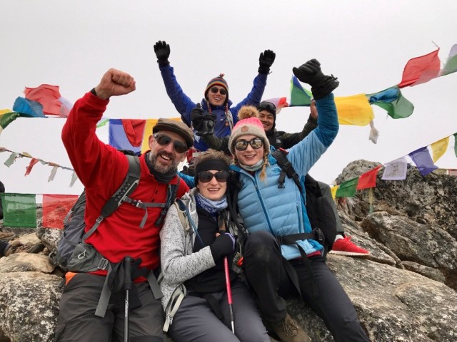
The ensuing hours were what can only be described as the most challenging physical task that I have ever set my mind to. Despite my layers and gear, my hands and toes went painfully numb, and I was not able to reach a pace where the blood would circulate enough to warm them. In fact, we struggled to find a pace at all. The slowest pace was not slow enough for the lack of oxygen in the freezing air (we’re talking about 50% the oxygen at sea level). And so we started and stopped, started and stopped, started and stopped. Even when stationary, I found the only way I could calm my breathing was to bend over double, as if winded from a 100m sprint (much to the horror of Govinda who would break his usual characteristic companionable silence to ask if I was – in fact – dying). In-between sucking in mouthfuls of thin air, the sun began to rise behind Everest, although it was not until we reached the summit, after a couple of hours of hard graft, that I was able to appreciate the views.

David had summited first, and after de-icing his frozen camera lens, had taken some stunning photos. Incidentally I had tried to take some rudimental shots on my iPhone, only finding that upon exposure to the temperatures, my carefully conserved battery, then at 30%, dropped instantly to 10% and then 1% within seconds. Maybe not then. Exchanging glances with fellow frozen trekkers that said “it was worth it”, we looked out onto Everest, the highest point above sea level on this dear planet we call home, a black peak framed by a dusky blue sky, snow plume at the summit, and warm sun rising from the Tibetan side. The South Col was clearly visible.


Back at the teahouse, we were elated and I felt that I had now truly completed the ascending part of our adventure. However, both Habiba and Bex were not in a good way. Habiba in particular had been sick all night; a chopper evac was arranged and she was swiftly flown to Kathmandu. Bex managed to start trekking for the day before also becoming too unwell to continue, and took another chopper down. The rest of us set off, aiming to reach Pheriche (4,371m / 14,340ft) by the afternoon, back down the valley via Lobuche and the Thukla Pass. By lunch time, Front Team was seriously exhausted. We had all had one of our worst night’s sleep, mainly due to the altitude (mine due to the worry of my lungs giving out on me) but spirits were as always high. Having arrived in Pheriche, we had our coldest afternoon wait thus far, and our first snowfall. As we sat bundled in all of our clothes and sleeping bags wrapped around us, the fire was actually lit early, which I think says something. Our jovial mood continued through the evening, as Becky unveiled a ‘Mars Bar Birthday Cake’ celebration for Nick (comprising a Mars Bar adorned with candles and accompanying party poppers she had carried all the way to EBC and back).


The next morning our group felt decidedly smaller. Having started with 9, just 6 pale faces around the breakfast table was an adjustment. For the first time David, our strongest trekker, was really struggling with an overwhelming sense of weakness. He did make it all the way back to Lukla, but found those last two days the hardest of the whole trek, was icy cold all of the time, and really had to dig deep to make it back on his own steam. The hill going up into Dingboche was a struggle, but the difference now was that we had descended sufficiently for there to be enough oxygen in the air to be able to set a slow walking pace on the ascents, and stick to it. We actually made it to Dingboche ahead of schedule, and jointly decided (after a snack break) to go one stop further for lunch by the Dudh Koshi river, where we had eaten on the way up. It took us about 45 minutes to descend the hill that had taken almost double that to ascend, the ‘Bohemian Rhapsody’ sing-along-hill.

After some well earned food, the first hour or so of the afternoon was decidedly uphill, but then levelled out and we were more aware of slowly losing altitude. The afternoon followed the winding mountainous dust path that we had stoically faced five days previously. We passed the stupas adorned with prayer flags and I was exceedingly aware of the amount of birds, birdsong and smell of pinewood again at this altitude. It was like coming back to life after the barren landscape further up. Coming into Namche felt like returning to civilisation and we wearily sat down at the (even more aptly named) Foot Rest Lodge again. After a breather, Nicky, Becky, Mike and I (David was resting) made our way to the Irish Pub. Free wifi, free phone charging and free popcorn with a drink – sold to the smelly trekkers at the bar! Mike opted for a well earned beer, I stuck with my classic honey and lemon – I was still hacking my lungs up. After dinner, Mike and I wandered the streets of Namche for souvenirs and trinkets to take home. My heart was warmed when I watched three local men feed a family of very timid, stray dogs. For the first time, I was able to be outside, stationary, and not freeze.
The next day was our final day of trekking, and as the sun shone on Namche, we set off along the dusty track all the way down the Namche hill, along with what seemed like everybody else within a 10km radius. For the first time, the route was positively busy, and we started to get twitchy that everybody else would also be vying for the first flight out of Lukla the following morning. Narayan reminded us that he was the man with all of the best contacts in the area and that, weather dependent, we would be on our way bright and early as planned. It pays to have a good guide, people. Becky and I had terribly low energy all day, and joked that we only had two modes: on or off. ‘On’ consisted of a slow but steady forwards shuffle. ‘Off’ was sitting down on a stone wall, rock or anything else really. We had remembered the hill we had descended on day one down from Lukla, and at the time had been content in the knowledge that we would not have to ascend it until our final day. Today was that day. But we felt so privileged to have been able to take part in the trek and see the sights that we had seen, that even that hill combined with our weary bodies could not dampen our spirits.

We arrived at The Nest at Lukla weary but undefeated, proud of our achievements. We spent the evening chatting and enjoying some Nepalese rum before turning in for the night. Narayan had indeed utilised his contacts and we were to be at the airport for the first flight out, weather dependent. After a sound sleep and hearty breakfast, we arrived to the chaos of Lukla airport: bags were thrown, ribs were elbowed, bodies were patted down and various random items were confiscated (Mike’s nail clippers, a German lady’s umbrella, my bottles of rum; although another lady was allowed to keep her lighter in her hand luggage – the only widely spoken about ‘illegal’ item…) and our passes were hastily stamped with the number ‘2’. We could only assume that this meant we were on the second flight out of Lukla as we were herded into a waiting area. There were as of yet no planes, and I made a swift dash back through security to grab my confiscated rum and stash the bottles in my hold luggage which was now waiting on the runway. In a matter of minutes, there were several planes on the runway, clean tourists were bundled off an aeroplane and we were bundled on. Take-off was much like deciding to go on a roller-coaster as a child: looking at it, deciding it looks fun, queuing to get on, getting on, realising that you have made a terrible mistake, wanting to get off. But as we made a tight turn and faced down the runway, utilising every metre available, the engines revved and my fear dissipated and was replaced with excitement as the adrenaline kicked in. Unlike the cloudy flight in, we were treated to spectacular views of the snowy mountains on our right, and luscious green mountainous regions to our left, periodically scattered with smallholdings and winding paths.

I have described this trip to people as just that – a trip, an adventure, an experience – but not a holiday. You will need a base level of fitness to get by, and a good level of fitness to enjoy your experience. If you are like me and do not suffer with the altitude, consider yourself very lucky. If you are travelling solo, and are also as lucky as I was, you will meet wonderful, inspiring people to travel with. I booked with Himalayan Scenery Treks and Expedition, and found the whole process brilliant from start to finish. I felt well looked after and safe through every part of the trip, and those who did become unwell were swiftly evacuated. Ram Krishna will pull strings and sort out all of your arrangements, from your arrival in Nepal, to a helicopter evacuation, and everything in between. Through the EBC trek, you will be honoured to see the sights that you will see, your horizons will be broadened and your expectations exceeded. I recommend it wholeheartedly.
info@himalayanst.com

Tips
- Try your hardest not to get cold. Easier said than done. I found it hardest after a full day of trekking, in the ‘cold hours’. You return to the relative comfort of a teahouse anywhere between 14:30 and 16:00 and usually sweaty, then have the wait until the yak dung fires are lit at 17:00. In these hours, I found that despite all of my high tech layering systems, I simply could sometimes not warm up. Drink copious amounts of honey lemon tea, fork out on a hot water bottle, do whatever helps. It is also prudent to walk in ‘too many’ layers, even on warmer days.
- On that note, do not, I repeat do not have showers to try and keep clean. They are cold most of the way up. Accept that your best friend is now the cheapest brand of babywipes you could find at the supermarket at home (was that just me?), accept that you probably smell, that everyone else probably smells, and that smelling bad will not stop you getting to EBC, but a cold shower induced chill might just.
- Eat, eat, eat. I lost my appetite somewhere above 4000m and struggled with the ‘sameish’ (spoilt Westerner alert) menu. However, myself and fellow lost-appetiters struggled through, sometimes taking over an hour to nibble away. You will need the calories and the fuel. You are not eating for pleasure, you are eating to try and give yourself the best advantage for the next day and not start on a deficit. If you can’t stomach much, opt for plain rice, chips or pasta (all readily available) and supplement with copious amounts of chocolate and nuts. Readily accept any snack from kind fellow team members. Snack while trekking too. Forget health and diets and sugar levels. This is survival, people!
- Don’t eat the meat. Just don’t. Why risk it? Harness your inner herbivore and delight in the many veggie options available on the menu. Theoretically the meat is safe around Lukla and probably up to Namche (less than a day’s walk for a porter), but I still wouldn’t risk it. But perhaps already being a veggie has me a bit biased.
- Drink lots of water! It’s one of the best things to do to try to avoid altitude sickness. As horrible as it was to start each day with a litre of chlorine tasting water from my hydration bladder whilst still semi-horizontal in my sleeping bag, I believe it helped. I bought my hydration bladder specifically because it holds 3L. I drank 1L upon waking, tried to get through another 3L before and during lunch, and another 3L the rest of the day. Hot drinks were in addition to this. I kept this routine up until Gorakshep where the acclimatisation process was almost over – what a relief! On the way down I drank considerably less.
- Buy a blood oxygen device in case your guide does not have one (he should). It will give you another indication of how you are acclimatising. A couple of the poor souls in our group who were choppered out had readings in the 30s (ideal readings should not be below 90, on this kind of trek Narayan told us that anything above 65ish is okay, but obviously higher is better).
- Take iron supplements. I started on a high dose about two months before the trek started. I had read informal accounts of this helping with high altitude trekking, and was willing to try anything to avoid having my dreams of EBC shattered by AMS. It makes sense, right? If oxygen is carried around the body by haemoglobin, surely upping your haemoglobin count (by taking iron) will up the amount of oxygen that your body can circulate, even at high altitudes? It’s hard to say what contributed to my escape from any AMS symptoms: the high iron dose for 2 months and throughout; I was taking a small dose of Diamox (half a 250mg tablet, morning and night until Tengboche when I started taking one whole tablet in the evening, half in the morning); drinking a lot of water; forcing myself to eat; pushing myself to complete all of the acclimatisation treks; and perhaps out of control factors such as general physiology pay a part. My blood oxygen saturation was consistently the highest in the group, my lowest reading was 83 at Gorakshep, our highest night’s sleep. I considered myself very lucky not to have to deal with the severe headaches and/or nausea that much of the rest of the group endured. Which leads me on to tip 8…
- Pack a pill for every eventuality. At least half of the weight of your day pack should be medicinal products (ok, slight exaggeration, but take heed). Predominantly painkillers, the strong ones with codeine and other such good stuff, as well as gastro related, cold and cough related, etc etc. If you are lucky like I was, you will end up donating most supplies to your suffering friends (and if you are lucky, you will be rewarded with extra snacks in return).
- Get the right insurance. Obviously nobody wants an emergency chopper evac, but it happens (three times in the case of our group), and you need to have insurance that covers you up to 6000m, unless you have a spare $5000 lying around. Most insurance companies will only cover you up to 3000m, so you will have to shop around. I used CoverMore, but there are several adventure companies who will cover to 6000m, but be prepared – it will cost you.
- For the best views, sit on the left side of the plane for arrival into Lukla and right side on departure.

Congratulations on a wonderful first blog post! You have captured the trek really well and made an informative and enjoyable read.
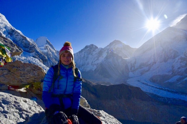
I love your cheesy trekker photo and the one of the goats, Did you take it with your iPhone? They look really close! I think you described the walk to Tengboche well, it’s a killer isn’t it? I enjoyed seeing your photos of Dingboche acclimatisation walk. Another killer walk but oh so worth it. It was one of my favourite days and places.I was surprised to read it snowed in Pheriche one your return journey. In April? Shows I have more to learn on that one.
You certainly capture two sides of how the trek can pan out, with three of your team having emergency evacuations. I think your tips are good, i hadn’t read about the iron supplements before but it makes sense.
My experience of the trek was one without headaches or aches and pains. Interestingly and anecdotally older people often manage the Base Camp trek better than younger people. One reason for this would be they have more money and time to spend on a longer trek. We my husband and I factored three extra days into our trek. So maybe you can talk your Mum and Dad into go too.
Are you planning another post about this trek? I look forward to your next post and your next adventure. Stay safe. Louise
LikeLiked by 1 person
Hi Louise,
Thank you! Cheesy trekker photo was indeed my iPhone 5s, I believe the goat photo might have been on an iPhone 7.
Yes, we were so lucky with the weather in general, but the snow that afternoon did take us by surprise! It didn’t settle though and was just a sprinkling. My favourite part had to be the satisfaction post Kala Patthar, but the treks still within the tree line (around Tingboche) were incredibly beautiful.
I think we were some of the lucky ones, not to suffer with the altitude. Your comment about acclimatisation days is so true. Very important to travel with a company who factor them in and give them the importance they deserve.
I don’t think I’ll write about this trek specifically again any time soon, but I will have posts about adventures in Iceland and Australia coming up soon!
Thanks Louise, you too. 🙂
LikeLike
Spectacular post and what a wonderful experience. Well done on completing such an epic walk. So much inspiration here for those looking to do this themselves.
LikeLike
Thanks so much Miriam!
LikeLike
Great photos and very interesting post. I enjoyed all the photos of the victorious trekkers! What a wonderful experience.
LikeLiked by 1 person
Thanks so much Anne!
LikeLiked by 1 person